The Zambezi RiverZambezi River means the “Great River” in the local Tonga dialect
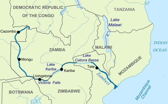
The Zambezi is the fourth longest river in Africa, after the Nile, Congo, and Niger Rivers. It is the longest east flowing river in Africa. It flows through six countries on its journey from its source in north-western Zambia to the Indian Ocean, an amazing 2 700 km. This river evokes mystery and excitement with few rivers in the world remaining as pristine or as little explored.
Zambezi River running along the Zambezi National Park in Zimbabwe The source of the mighty Zambezi River lies at about 1 500 m (4 900ft) above sea level in the Mwinilunga District, very close to the border where Zambia, Angola and the Congo meet. From there it flows through Zambia, Angola, Namibia and Botswana then back along the border of Zambia and Zimbabwe finally discharging into the Indian Ocean at its delta in Mozambique. The area of its catchment basin is 1 390 000 square km which is half that of the Nile.
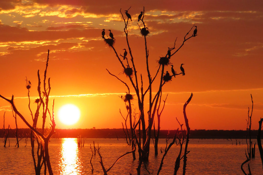
The length of the Zambezi River The Power of the Zambezi River has been harnessed along its journey at two points, the first being Kariba Dam in Zimbabwe and the second Cahora Bassa Dam in Mozambique. Both these dams are sources of hydroelectric power and supply a large portion of power to Zambia, Zimbabwe and South Africa. Recently worrying reports have popped up in the press that the Zambezi Seaway Scheme, a project to open up the Zambezi to enable the transportation of goods and minerals from the hinterland, is back on the cards. Click here for full details and to leave your comments. For years there has also been talk and plans of another Hydroelectric Dam to be built in the Batoka gorge just below Victoria Falls, of major concern is that these plans are very much alive again. To find out more please click on this link "Batoka Gorge Dam Project" as we continue to follow and oppose this threatening project. The rivers beauty has attracted tourists from all over the world and provides great opportunities for game viewing and various water sports. Hippopotamus, crocodiles, elephants and lions are some examples of wildlife you will find along various parts of the Zambezi River. I suggest that we look at this amazing river in three sections: Upper ZambeziFrom the source the river flows to the south-west out of Zambia and into Angola for about 240 km (150miles). When it re-enters Zambia it is approximately 400m (1300ft) wide in the rainy season and is fast flowing at Cholwezi rapids and the Chavuma Falls. The river runs south now for a distance of about 800 km (500miles) and in this distance only drops about 180m (590ft). It is very slow flowing for most of this section as it enters an area known as the Barotse Floodplain where the width of the river reaches up to 25 km (16miles) in the rainy season. The upper part of the Zambezi River is only sparsely populated by pastoralists, farmers and fishermen. During the rainy season when the plain is in flood a ceremony known as the Ku-omboka Ceremony take place as the local people move to higher ground to escape the flood waters. One local folk law is that the Zambezi River has a spirit called Nyami Nyami – this spirit brings them water to grow their crops and fish to eat – and so they call the river “the river of life”. It then turns easterly and forms the border between Zambia and Namibia this is at the Katima Mulilo rapids.
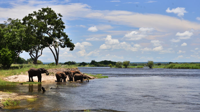
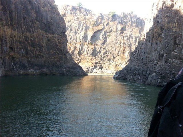
The Zambezi River above the Victoria Falls Eventually it meets the Chobe River and briefly forms a border with Botswana, before becoming the border between Zimbabwe and Zambia. It is at this point that the four countries; Botswana, Namibia, Zambia and Zimbabwe meet. The river then flows about another 80 km down towards Victoria Falls. This section above the falls is where tour operators run lots of exciting activities including kayaking, canoe trips, river cruises and daily floats on both the Zimbabwe and Zambian sides. This is a spectacular section of the river with many islands and channels, crystal clear waters and sandy beaches. It teams with birds and wildlife. The Zimbabwe side is a national park called the Zambezi National Park whilst on the Zambian side there are many small lodges which blend into the banks of the river, plus about 20kms of the river's shoreline lies within the Mosi-oa-Tunya National Park. The Middle ZambeziThe Victoria Falls are considered the boundary between the upper and middle Zambezi. For the next 500 km the river serves as the border between Zambia and Zimbabwe. Below the Falls the river continues to flow due east for about 200 km (120miles), cutting through gorges of basalt rock between 200 to 250 metres (660 to 820ft) high. It is in these gorges where the commercial white water rafting now takes place. The Zambezi River is graded as a grade 5 river. This is the highest grade that a river can be graded for white water rafting, meaning this is as wet and wild as it gets. The Victoria Falls also serves as a backdrop for many other adventure sports including the famous bungee jump from the Victoria Falls Bridge.
The Zambezi under the Falls running in the gorge The river drops 250m over the next 200 km before entering Lake Kariba. The Kariba Dam which was completed in 1959 is one of the largest man-made lakes in the world. The hydroelectric power generated at the dam provides electricity for much of Zambia and Zimbabwe. Lake Kariba is 226 km long and in places up to 40 km wide and supports a thriving commercial fishing industry and is a fantastic tourist attraction. With its spectacular scenery, stunning sunsets, great fishing and boating opportunities it is one of the finest places on this planet for a holiday. The weather here is mostly sunny and fine but it does get very hot in mid summer, even mid winter days are warm and the nights are balmy. From the Kariba dam wall the river heads east again towards Chirundu. Beyond Chirundu, the river is flanked by the Lower Zambezi National Park in Zambia and Mana Pools National Park in Zimbabwe. This is the stretch of the river that the famous canoe safaris are run.
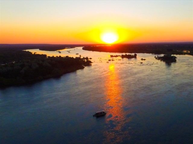
Sunset on Lake Kariba (photo by Changa Safari Camp) Tourists have the opportunity of paddling down the river and camping overnight on the banks or more luxurious trips offer accommodation in one of the safari lodges along the way. Wonderful sightings of wildlife are experienced as the canoes slip silently by them, and encounters with Hippopotamus can be quite exciting. This middle zone of the Zambezi river supports one of the most important wilderness areas in Africa. The middle Zambezi ends where the river enters Lake Cahora Bassa which was constructed in 1974. Formerly the site of dangerous rapids known as Kebrabassa, these rapids made navigation by large vessels up the Zambezi impossible for the early explorers and for this very reason the development of the inland was slower than had they not been there. The Lower ZambeziThe lower part of the river from Cahora Bassa down to the Indian Ocean is navigable by large vessels. This section is 650 km (400miles) in length, the river is shallow in many places especially during the dry season as the river enters a broad valley and spreads out over a large area. Only at the Lupata Gorge 320 km (200miles) up from the mouth does the river flow between high hills and a gorge is formed. Elsewhere it flows gently with many small channels to explore along the way. The river bed is sandy, and the banks are low and reed-fringed, however during the rainy season these streams join to become one fast flowing river.
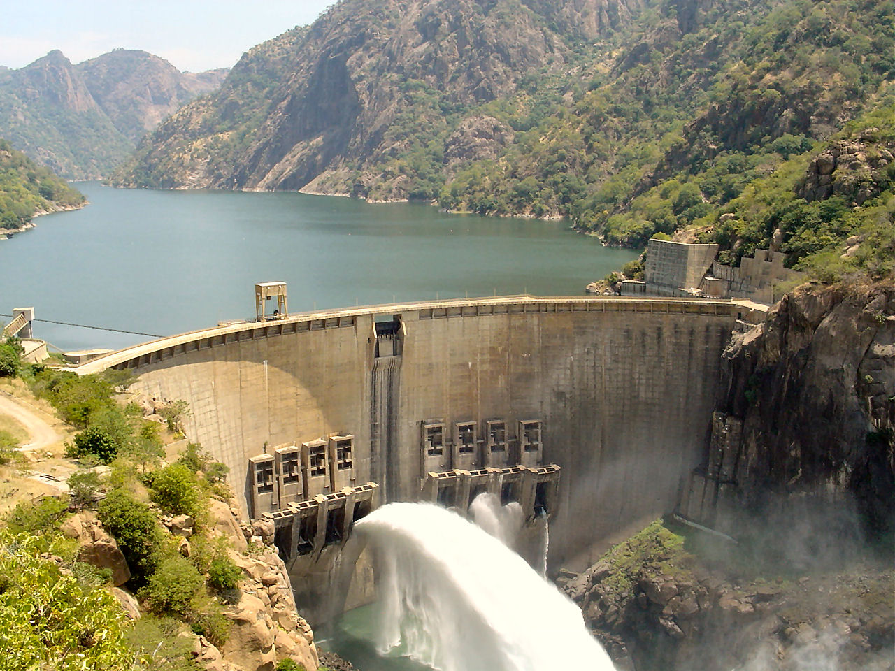
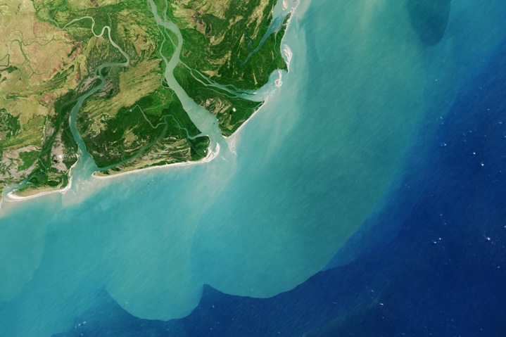
The Cahora Bassa Dam - Mozambique The Zambezi's DeltaAbout 160 km (100miles) from the mouth, the Zambezi receives water from Lake Malawi through the Shire River. On approaching the Indian Ocean the river splits up into a number of branches and forms the Zambezi Delta.
The Zambezi Delta - Indian Ocean A sand bar obstructs the four principal mouths, being the Milambe, Kongone, Luabo and Timbwe. To the north a branch called Chinde has a minimum depth of 2m at the entrance and 4m a bit further in; this is the branch that is used for navigation. The delta has been effected by the building of the Kariba and Cahora Bassa dams and it's about half as wide as it was before these were finished.

|
Follow!
   THREATS TO THE ZAMBEZI RIVER The Zambezi Seaway plans to open up the Zambezi for the transportation of minerals from the hinterland. Action needs to be taken to stop this happening. Read the full story here
The Batoka Dam proposal will flood
the Batoka gorge below Victoria Falls, effectively wiping out the white water
rafting and destroying the beautiful gorge and its ecosystem. |
||||
|
|
|||||
|
|
|||||
|
| |||||