Kariba DamHalfway between the source of the Zambezi River and its mouth, lies the world's largest man-made reservoir, a safari and fishing haven - Lake Kariba
Is Lake Kariba Worth Travelling To?
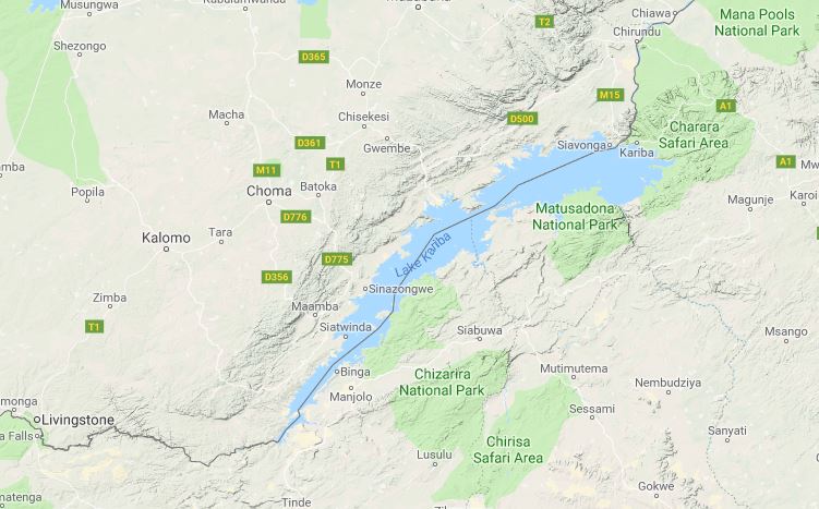
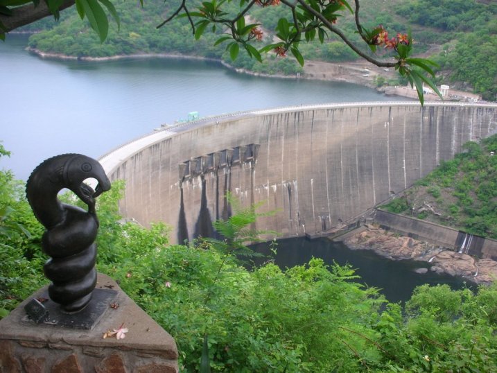
In our opinion... absolutely! but Lake Kariba or more correctly Kariba Dam, often gets overlooked by international tourists, possibly because it is not that well publicized or known about by foreign Travel Agents, but this is a big mistake, as it's an absolute vacationer's paradise. There is not a Zimbabwean out there who doesn't hold Kariba very close to their heart. Although a bit difficult for tourists to get to, it is known for gorgeous sunsets and exciting fishing, as well as beautiful scenery, and impressive game viewing, particularly in the Matusadona National Park. The vastness of the lake allows for multi-day excursions from one end of the lake to the other in one of the many Kariba houseboats or on the Kariba Ferry. A variety of accommodation options including camping and lodges to luxury safari camps as well as the houseboats, cater for different budget groups. The Zambian side does not have the same magnificence as the Zimbabwean shoreline. For one, the game is fairly non-existent on the northern bank and second, it lacks the stunning backdrop of the Matusadona mountains that the Zimbabwean side has. Is Lake Kariba the Biggest Man-made Lake in the World?Lake Kariba, when constructed was the largest dam wall and artificial lake in the world, but although record has since been surpassed by others dams, it is still the world's largest man-made reservoir by volume, making the Zambezi River home to two world greats - the other being the largest waterfall in the world, the Victoria Falls. Kariba's reservoir volume is 185 billion m3, the surface area covers about 5500km2, and it extends for more than 280km, with a maximum width of 40kms. It is located just about halfway between the source and mouth of the Zambezi River, and is 200kms downstream of the Victoria Falls. The lake lies on the border between Zimbabwe and Zambia, as does much of the Zambezi River. How Big is the Kariba Dam Wall?The Kariba Dam has a double-arch wall - curved both vertically and horizontally. It stands 128m high, 617m long and 13m wide at it's crest, and 24m wide at the base. The wall spans across the Kariba gorge, creating a border crossing between Zimbabwe and Zambia, where people and vehicles can go from one country to the other. How Did Kariba Get its Name?The name Kariba was derived, by the Europeans from the local Shona word 'kariva' or 'kariwa' meaning 'little trap' or 'bridge'. There are various explanations of this but one of them is that before the dam was built, the Zambezi river, at this gorge was funnelled into a narrow neck no more than 100 meters wide. The powerful water carved it's way through a large granite block, leaving the top to form a natural bridge. This arch looked like a large traditional fish trap, hence the name. When Was Lake Kariba Built and How Long Did it Take to Fill Up?Construction on the Kariba Dam wall began in 1955 and was completed in December 1958. Northern Rhodesia (now Zambia) and Southern Rhodesia (Now Zimbabwe) were in need of hydroelectric energy, particularly for the production of copper, especially in Northern Rhodesia where copper was being produced and was in high demand after the second World War. By 1960, Harare, Bulawayo and more towns in the south, as well as towns in Zambia were receiving electricity supplied from Lake Kariba. The story of the construction of this huge dam is not complete without the myths and mystery involving the Zambezi River god and his home. Read the very interesting story of Nyami Nyami in African Mythology. After construction was complete it took another 5 years for dam to assume its present day dimensions. During this time, there was a massive relocation operation, with 22000 people moved into Zimbabwe, and 35000 people into Zambia, along with 6000 animals from the river valley. The relocation program caught international attention and was known as Operation Noah, headed by Rupert Fothergill. The operation took 6 years to complete, and animals were moved into the Matusadona and Chete safari areas. What Was Lake Kariba's Construction Timeline?
1955, August: The Federation of Rhodesia & Nyasaland called for tenders for the
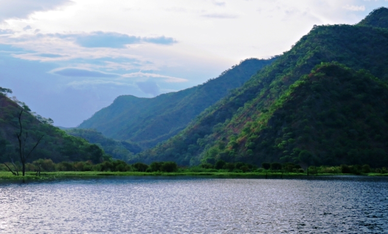
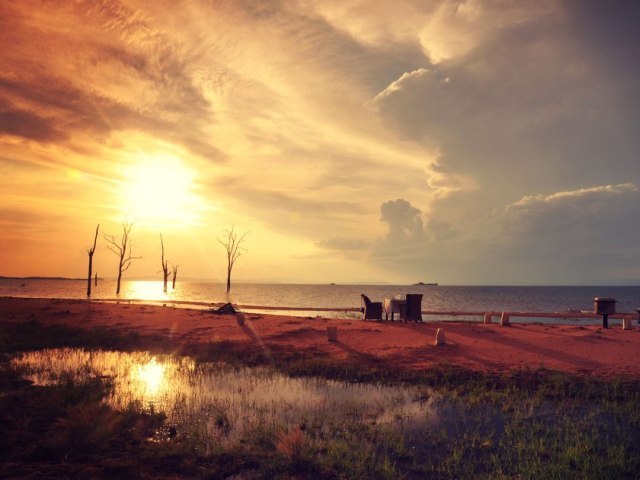
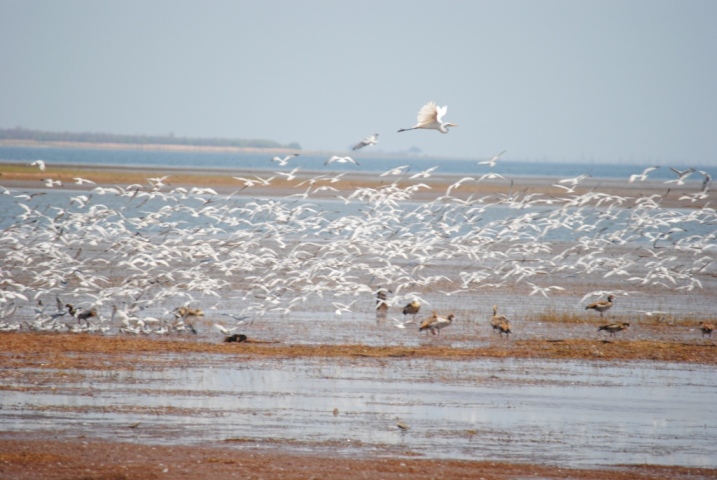
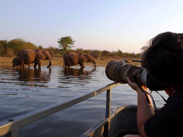
construction of the dam; Other facts about KaribaIn the late 1960's, Lake Kariba received shoals of kapenta (small sardines) from Lake Tanganyika, and this was the beginning of the commercial fishing industry for which Kariba is known. The indigenous Tiger fish have thrived on the kapenta, and further contributed to tourism in the area. There are several other species of fish in the lake, and altogether, they make for some of the best sport fishing anywhere. Kariba is a major source of hydro-electric power for both Zimbabwe and Zambia. However, due to time and perhaps some seismic activity over the past few decades, Kariba must undergo an upgrade for the next few years. The plunge pool below the wall has been eroding the foundation, and studies suggest that in time, the dam could give way, which would be catastrophic. This time, the work has been contracted to French engineering firm Razel-BEC. Safari Areas Around Lake KaribaMatusadona National ParkJust west of Kariba Dam wall is the Matusadona National Park. It has different ecological zone which include the area along the shoreline of Lake Kariba, the Zambezi Valley floor, and the escarpment which is a woodland area. During Operation Noah, much of the rescued wildlife found refuge in this area, and by 1963, Matusadona National Park was declared a game reserve. The rejuvenative grass found along the shoreline is a great source of food for buffalo, kudu, waterbuck, zebra and impala. The healthy population of these and other game makes it a good home for predators such as lion, cheetah and leopard on the land, and crocodile in the shallows of the lake. Like Matobo Hills, Matusadona is an Intensive Protection Zone, being home to relocated black rhino. The easiest way to access the park is by flying to Kariba town or Bumi Hills, then taking a boat into the reserve. Chete Safari AreaUpstream from Matusadona National Park is the Chete Safari Area. This hilly and rocky area is difficult to access by car or game vehicle. Chete is actually a controlled hunting area, done by boat, vehicle and on foot. Islands of KaribaLake Kariba has several islands both on the Zimbabwean and Zambian side of the border, which make for idyllic getaways, staying at beautiful island lodges or safari camps with vast scenic views of the lake. The islands include Maaze Island (Zambia), Mashape Island (Zambia), Chete Island (Zambia), Sekula (Zambia), Sampa Karuma (Zimbabwe), Fothergill (Zimbabwe), Spurwing (Zimbabwe), Starvation Island (Zimbabwe), Antelope Island (Zimbabwe), Bed Island (Zimbabwe), and Chikanka (Zambia)." Towns Around KaribaThe town of Kariba, which was originally built for the people that worked on the construction of the dam wall, is a small town in Zimbabwe which lies in the north-eastern end of the lake, near the dam wall. Binga is on the south-western side of the lake, closer to the Victoria Falls and Hwange National Park. Siavonga is on the Zambian shore of Lake Kariba, and this town has grown to be the tourist capital for Kariba on the Zambian side. Together with Sinazongwe, Siavonga was created for the displaced Tonga people who were made to move for their safety as the waters of the Zambezi were expected to flood their villages. Sinazongwe was set as the administrative capital, just 3.5hours from Livingstone town, and 3.5 hours from Lusaka. Sinazongwe is to Binga what Siavonga is to Kariba town. "The Zimbabwean side of the lake has about 1 000km of shoreline and a number of islands. Elephants can often be seen swimming between the islands and the shore, a sight so typical of Lake Kariba." Interesting Facts
• "Both Southern Rhodesia (Zimbabwe) and Northern Rhodesia (Zambia) were in contention as it was thought that the Kafue River Gorge site in Northern Rhodesia was preferable to Kariba. The matter was solved in 1951 by a board of experts known as “The Panel” who all agreed that the dam be built on the Zambezi River, at the Kariba Gorge site."
Combining Kariba/Matusadona with Mana Pools and Victoria Falls gives a fantastic experience of the different section of the Zambezi River, from the upper Zambezi (and perhaps Chobe), to the middle Zambezi and the lake, and the final section which is the Lower Zambezi in Mana Pools. Have a look at some Zimbabwe safari ideas taking you around different destinations in Zimbabwe. Last update: 9 November 2022
Have A Great Story About Kariba?Share your story with us and other guests What Others Have SharedClick below to see contributions from other visitors to this page...
The settling Lake Kariba Not rated yet
 |
Follow!
|
||
|
|
|||
|
|
|||
|
| |||